
I made a lot of good friends in West Tennessee through geocaching. One, who goes by the name “Hoot Owl” (and can do a pretty fair imitation of said animal), is one of the best friends I’ve ever had, and I miss hiking in the woods with him and my other WTN friends terribly. Another good friend goes by the name “CGeek.” Wanda is a computer wiz, and largely responsible for keeping the Geocachers of West Tennessee website running after the original designer had to step back. Wanda has a travel bug. No, that’s not an insect in your luggage.
Travel bugs are items of significance to their owners, to which they have attached numbered tags that can be logged on the Geocaching.com website. You can watch its movements, track its mileage, and folks sometimes post pictures of their travels. I’ve got quite a few of them myself. One was a small replica of my black 2003 Dodge Ram. This bug made it all the way to Baghdad! If you remember seeing the big “crossed swords” monument on TV, there used to be a geocache in the right hand (apparently, you could climb up into the monument). Unfortunately, one of the “occupational hazards” of being a travel bug is the tendency to get lost or stolen. It’s hard to complain, though: once you leave something in a box in the woods, you pretty much lose control over it.
Wanda’s bug is a Panda Bear. It started its travels very close to my former (and still for sale!!) home in Arlington, TN. I knew about the bug and long ago placed it on my “watchlist.” This means I get an email from Geocaching.com anytime someone posts a log to the bug’s travel page. Wanda’s bug is one of the more successful bug’s I’ve seen, having made it all the way to China and back safely.

Last weekend, Labor Day, we traveled up to Washington State to see my mother-in-law, who lives just southeast of Seattle in Auburn. Near Auburn is a place called “Tiger Mountain,” which has a neat series of trails criss-crossing up the side, and a few geocaches. One, called “Tiger Mountain's Logging Legacy,” has been on my watchlist (and my to-do list) ever since I first discovered geocaching back in 2004. In all of our trips up to mom’s house, I’d yet to set aside enough time to do it. But this weekend, while we were at mom’s house, I got an email saying that Wanda’s bug had just been placed in “Iverson Railroad,” another cache about a half mile from Logging Legacy. What are the odds that your friend's travel bug, 1,800 miles from home, gets dropped in a cache just a few miles from Grandma's house on a weekend that we are in town visiting? I purposed then and there to head up to the cache the next morning and pick up this link to my West Tennessee friend. What I got was not only a travel bug, but one of the best cache hunts I’ve ever been on!
Overview map of Tiger Mountain trails:

The next morning, Labor Day, I got up early and headed out for Tiger Mountain. I arrived at the parking area about 8:30, with just a few cars of mountain bikers already there. Not knowing the trail system, I simply headed up the gravel road vaguely toward the cache. About a half mile and 100 feet higher, I spotted a trailhead, and investigated. The sign at the trailhead gave instructions on what to do if you encounter a cougar or a bear!! My kind of cache hunt!!
The trail was well worn, but seemed to lead away from the cache. We had to leave to get back home, at least by mid-afternoon, since I-5 can be a disaster between Seattle and Portland. I needed to make the hunt as quick as possible, so I backtracked to the road and continued toward the cache. Not as scenic, perhaps, but quicker. I encountered a couple of hikers, two bikers, and a jogger, but the road was mostly deserted. Why, I’m not sure, the weather was fabulous, sunny and about 65-70 degrees!

About a mile and a half later, I could tell from the GPS that the cache was going to be off the road to my right, so I started looking for a trail. Shortly, I came upon the “Iverson Railroad” trail; the same trail I had checked out before. This time, I was within about 500 feet of the cache, and started off.
This trail was well marked, but undergrowth, especially poison oak, encroached like the grasping arms of a would-be tackler reaching for a running back. I am fortunate in that I am not allergic to poison oak or ivy. I’ve had one or two VERY minor spots on my hands, but just don’t seem to react to it much at all. So I’ve never paid much attention to it. Up here, Western Poison Oak is like kudzu, second only to blackberry vines. After being fussed at (good-naturedly) for my “blatant disregard” for this vegetation after my first cache hide up here in Oregon, I’ve tried to learn what it looks like and avoid it. How anyone that is allergic to it can cache at all up here escapes me. But, I digress. In short order, I found the spot on the trail where I needed to head off into the woods, which was well marked by the signs of a geotrail. Shortly, I had the “Iverson Railroad” cache in hand, & sat down on a root to open it up, very happy to see a little panda peeking out at me.
With mission accomplished, I checked my watch and the distance to Logging Legacy. Thinking to myself, “Yeah, I’ve still got time,” (ala “Mr. Incredible,” if you have seen that movie, which I highly recommend if you have kids). I waffled a bit about which was to go: back the way I came to the road, or continue up the trail. I eventually chose to go back to the road.
I had to follow the road for about another half mile to get to another trailhead that led to the next cache. I have to admit, I’m not in great shape, and I was huffin and puffin a little up this road that was a steep as steps in some places. As I approached a trailhead, I stepped aside to read the signs. A friendly fella came along and asked if I needed directions. Knowing that all I had to do was follow the road to get back to my car, I thanked him and said no, I was just reading the sign. That by itself wouldn’t have been so bad, but he was at LEAST 20 years older than me and he was JOGGING up the hill!
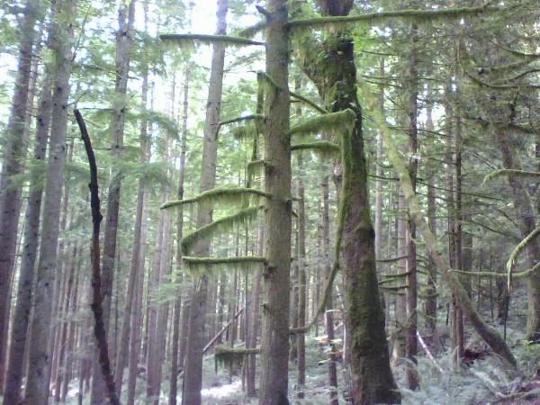
Heading off trail here was like entering the woods of Lothlorien! Moss hung thickly from tree limbs, the cedar and fir trees towered above the hillside, reaching at least 100 feet high!
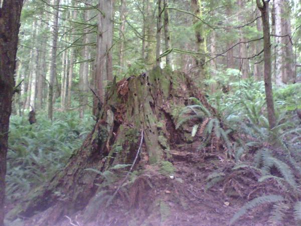
Enormous stumps, some must have been 7 or 8 feet across, gave evidence of Tiger Mountain’s “logging legacy.”
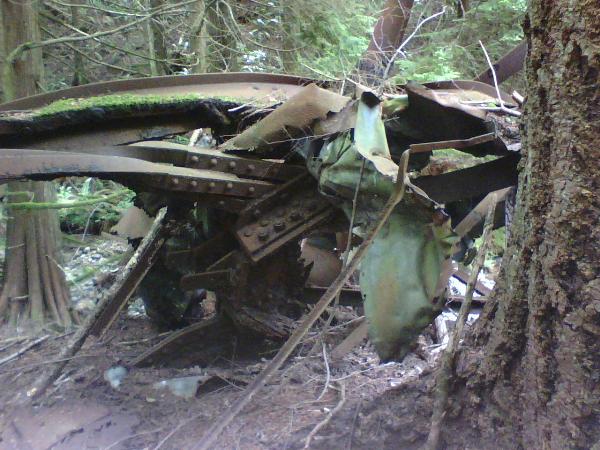
The cache site is near the site of a 1925 train wreck, and the woods are still littered with debris from the 82 year old wreck.
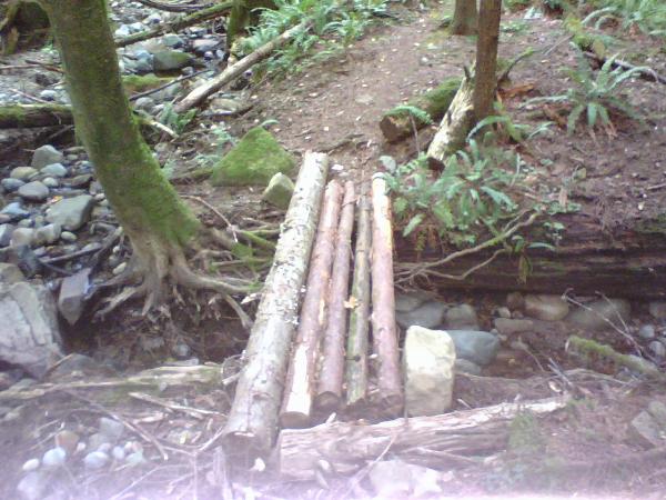
I also had to cross a neat little homemade log bridge.
Once at the site, I had to look for a while because the heavy tree cover was playing havoc with my GPS signal. Finally, I just glanced at a tree and thought it looked a little unnatural, and bingo!
There was another cache just about 1,000 feet away called “Karl's Peak,” but I was alone, I’d left without my hiking stick and only in tennis shoes, so I decided to let that one wait for another day. Heading back out, I was really missing my buddy Hoot Owl, if he'd been there, we'd have found Karl's Peak! Six plus miles round trip, over 400 feet of elevation change, quiet you can only find deep in the woods, this was our kind of cache hike!
Round trip took about 3 hours from mom’s house and back. For my trouble, I got a lot of good exercise, fresh air, a long distance connection with a friend through her travel bug, some time alone in the woods, and two smiley faces; three if you count the one I was wearing!
1 comment:
Some time back, I remember reading about Wanda's little bear and its' mission to visit China. I thought that was such a great travel experience, even if you had to travel virtually. The fact that it turned up in a fellow GOWT member's hands is great.
I enjoyed your narrative of your hunt, especially your desription of the woods and their likeness to Lothlorien. That has to be one of my favorite literary destinations. I'm glad to know that you too have some light-hearted sensibilities inside.
I look forward to reading more about your adventures in the great northwest.
Post a Comment